
Road and Intersection Safety
York Region reviews roads and intersection safety to identify priority locations for improvements that support the goals of the Vision Zero Traveller Safety Plan, including reducing severe collisions by 10% over five years. These findings guide enforcement, road and intersection improvements, new infrastructure design and public education.
Keeping York Region’s roads safe is everyone’s responsibility.
York Region maintains more than 4,400 lane kilometres of roads and 900 traffic signals, working continuously to improve safety for all road users. York Region is focused on reducing preventable collisions and saving lives through data-driven actions and increased public awareness.
Reducing Speed
Speed management plays a critical role in improving road safety across York Region. Almost half of all injury and fatal collisions are linked to aggressive driving. Speeding remains the most common traffic offence on Regional roads. Collisions involving pedestrians and cyclists are especially severe, resulting in injury or fatality in more than 80% of cases.
Through a data driven speed limit review process, speed limits are set and regularly reviewed to reflect roadway design, surrounding land use and operating conditions, supporting safer travel for all road users.
Noncompliance with the posted speed limit, dangerous and unsafe driver behaviour are enforcement issues. If you witness erratic driving/vehicle-operating behaviour that is an immediate danger to public safety, please call 9-1-1. Should you observe dangerous or unsafe motorist behaviour, you may contact York Regional Police directly through the following:
Slowing Down Traffic in Communities
York Region uses a range of traffic calming measures to encourage slower, safer driving. These measures increase driver awareness and reinforce safe driving behaviour, especially in areas with vulnerable road users.
Measures such as Senior Zones, Gateway signs, “SLOW DOWN” pavement markings create a visual narrowing effect that naturally prompts drivers to reduce speed. They are installed in rural villages, near schools, retirement homes and other high risk locations where people walking, cycling or using mobility devices need added protection.
Speed monitoring boards provide real time feedback by displaying a driver’s speed as they pass. This immediate visual cue encourages drivers to stay within the posted speed limit and supports safer driving behaviour. Speed data collected from these boards identifies areas of persistent speeding and guides future enforcement and safety planning.
Impact: These combined measures have reduced collisions by up to 15%, lowered operating speeds by up to 5 km/h and improved speed limit compliance by up to 51%.
Reducing Speed in School Zones
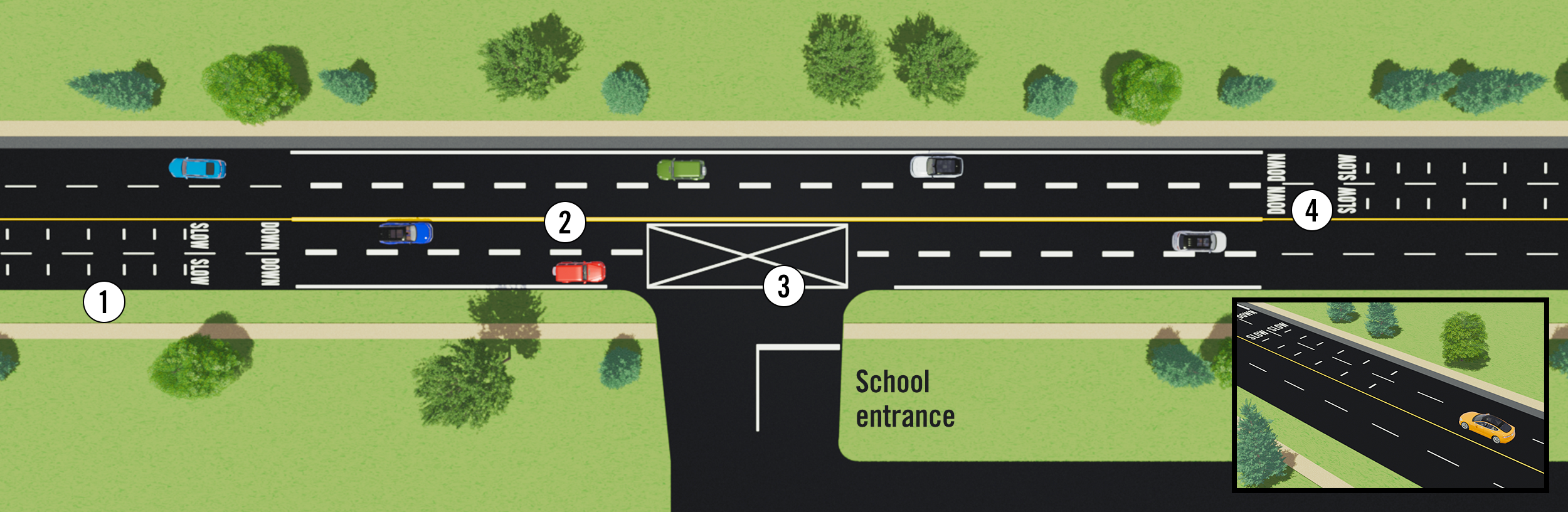
York Region has reduced speed limits in more than 60 school zones.
In July and August 2026, York Region is introducing enhanced pavement markings in school zones to encourage drivers to slow down and improve school zone safety.
Enhancements include:
- Speed reduction pavement markings (optical speed bars) to signal drivers to slow down
- Wider, more visible pavement markings, including centre lines, lane lines and edge lines, helping drivers better understand lane position and road alignment
- “Do Not Block” pavement markings at school entrances to improve access and visibility (where applicable)
- Upgraded school zone markings
School zone locations
- Aurora High School/Wellington Public School, Town of Aurora
- Mount Albert Public School, Town of East Gwillimbury
- Sutton District High School, Town of Georgina
- King City Secondary School/King City Public School, Township of King
- St. Robert Catholic High School, City of Markham
- Newmarket High School, Town of Newmarket
- Walter Scott Public School, City of Richmond Hill
- Tommy Douglas High School, City of Vaughan
- Whitchurch Highlands Public School, Town of Whitchurch-Stouffville (complete)
Work will occur overnight to help minimize traffic disruptions. Access to schools will not be impacted.
These enhancements are part of a pilot project being introduced in nine school zones across the Region in 2026, with one school zone selected in each municipality. The pilot launched in June with the installation of enhanced pavement markings at Whitchurch Highlands Public School.
All enhancements will be completed before students return to school in September. If successful, the program may be expanded to more school zones between 2027 and 2029.
This initiative supports York Region’s Vision Zero Traveller Safety Plan. The project is designed to encourage drivers to slow down and improve awareness around schools, helping keep students, families and all road users safe.
Changing Speed Limits on Regional Roads
Through a data-driven speed limit review process, speed limits are set and regularly reviewed to reflect roadway design, surrounding land use and operating conditions, helping support safer travel for all road users.
York Regional Council reviews and approves speed limit revisions on Regional roads annually. When speed limits are revised, clear signage is installed to inform drivers, including temporary “NEW” signs for the first 60 to 90 days during the transition period.
Reduced speed limit locations for 2026:
King-Vaughan Road in the City of Vaughan:
- One kilometre west of Keele Street to one kilometre east of Keele Street - 70 km/h to 60 km/h
Leslie Street in the Town of East Gwillimbury:
- 230 metres north of Mount Albert Road/Farr Avenue to Doane Road - 80 km/h to 70 km/h
- 320 metres south of Queensville Sideroad to 675 metres south of Queensville Sideroad - 40 km/h to 50 km/h as Queensville Public School was relocated
Queensville Sideroad in the Town of East Gwillimbury
- 800 metres east of Yonge Street to 2nd Concession Road - 70 km/h to 60 km/h
King Road in the Township of King:
- 135 metres west of 10th Concession to 200 metres east of 10th Concession - 80 km/h to 50 km/h
- 190 metres east of 11th Concession to 135 metres west of 10th Concession - 80 km/h to 70 km/h
17th Sideroad in the Township of King:
- Jane Street to Dufferin Street - 60 km/h to 50 km/h
Woodbine Avenue in the Town of Whitchurch-Stouffville:
- 200 metres north of Marjorie Drive to 800 metres north of Aurora Road - 80 km/h to 70 km/h
- 180 metres south of Bloomington Road to 259 metres south of Vandorf Sideroad - 80 km/h to 70 km/h
Request Speed Limit Change
Use this online service to request a decrease or increase in speed limit on Regional roads.
Improving Road Safety
York Region is taking targeted action to make roads and intersections safer for everyone. Intersections are critical locations for reducing collisions and preventing serious injuries.
York Region implements road and intersection improvements using data to manage traffic movements, reduce speeding, clarify right of way and protect vulnerable road users, including pedestrians and cyclists.
Making Intersections Safer
As part of the Vision Zero Traveller Safety Plan, York Region uses safety measures to reduce conflicts, improve driver awareness and support safer travel for all road users. Measures are selected based on collision history, traffic volumes, roadway design and surrounding land use.
Examples include:
- School and community safety zones: these zones strive to improve safety on roads where public safety is of special concern given presence of vulnerable road users, including seniors and students. They include “SLOW DOWN” pavement markings, reduced speed limits and new large speed feedback boards to promote awareness and compliance to speed limit
- Pavement markings and signage: large “SLOW DOWN” pavement messages provide clear reminders for drivers to reduce speed, particularly where children and seniors are present. In rural areas, the pavement markings are paired with gateway safety features, including community name signs with speed limits and pedestrian symbols. Together, these measures create a visual narrowing effect that helps calm traffic
- Senior safety zones: Senior Zones and Extended Walking Times at Signals are implemented near retirement homes and long-term care facilities. These zones include special signs warning drivers about seniors, large "SLOW DOWN" messages painted on the road and longer crossing times at nearby traffic lights to give seniors more time to cross safely
- In 2026, York Region introduced 11 Senior Zones on Regional roads near retirement homes and long-term care facilities:
- Yonge Street, north of Bloomington Road, Town of Aurora
- Yonge Street, north of St. John's Sideroad, Town of Aurora
- Mount Albert Road, west of Highway 48, Town of East Gwillimbury
- Morton Avenue, east of The Queensway South, Town of Georgina
- Woodbine Avenue, north of Apple Creek Boulevard, City of Markham
- Davis Drive, west of Prospect Street, Town of Newmarket
- Highway 27, south of Nashville Road, City of Vaughan
- Dufferin Street, south of Teston Road, City of Vaughan
- Pine Valley Drive, south of Villa Park Drive, City of Vaughan
- Ninth Line at Sunset Boulevard, Town of Whitchurch-Stouffville
- Ninth Line, north of Bloomington Street, Town of Whitchurch-Stouffville
- In 2026, York Region introduced 11 Senior Zones on Regional roads near retirement homes and long-term care facilities:
- Speed feedback boards: these devices monitor excessive speeding and have been shown to increase compliance to the posted speed limit. The board measures the speed of passing vehicles and displays it as they pass, encouraging drivers to slow down
- Turn restrictions: use time-based or movement-specific restrictions to improve safety and traffic flow at intersections
- Dedicated left turn signals: permits left turns only when a green arrow is displayed to improve safety and reduce collisions. Opposing traffic and pedestrians crossing are not permitted
- No Right Turn on Red restrictions: Restricts right turns during red signals to reduce conflicts and protect pedestrians and cyclists. Restrictions include static signage and digital signage
- Red Light Cameras: support compliance with traffic signals and reduce severe right-angle and turn-movement collisions
- All-way stops: all vehicles must come to a complete stop, improving safety and clarifying right-of-way
Learn About Traffic Signals and Pedestrian Crossings
York Region manages and maintains more than 900 traffic signals on Regional roads to support safe and efficient travel. Traffic signals are installed and operated using a data driven approach that considers traffic volumes, pedestrian and cyclist activity, sightlines and collision history to safely assign right of way at intersections.
Pedestrian Crossovers
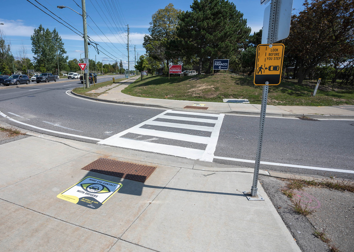
Pedestrian crossovers provide designated crossing opportunities where there is demand and the location does not meet the provincial criteria for traffic signals. They use standardized signs and pavement markings, and at some locations, flashing lights and push buttons to clearly communicate pedestrian right of way. To be eligible for a pedestrian crossover, the location must have a speed limit of 60 km/h or lower, have lower traffic volume and no more than four lanes.
Pedestrian Signals and Push Buttons
Pedestrian signals at signalized intersections provide clear crossing indications, such as the “WALK” symbol, and countdown timers. Pedestrians must press the push button to activate the pedestrian signal, ensuring adequate crossing time. Pedestrian signal timing is regularly reviewed by staff and seasonal adjustments are made as needed.
Watch the Pedestrian Push Button video
Audible Pedestrian Signals
Audible pedestrian signals provide accessible crossing information for people who are blind, visually impaired or deaf blind by indicating when and where it is safe to cross. The pedestrian push button must be pushed and held for at least three seconds to activate audible tones. If the button is not held down for at least three seconds, the audible tone will not be activated even though the walking person display appears. All audible pedestrian signals meet Accessibility for Ontarians with Disabilities Act (AODA) requirements.
Traffic Signals
York Region regularly studies intersections to determine whether traffic signals are warranted, in accordance with the Council-approved Traffic and Pedestrian Policy and Ministry of Transportation Ontario traffic signal criteria. This helps ensure a consistent approach to implementing traffic and pedestrian signals across the Region and Province.
The Region also reviews traffic signal timing and operations in response to evolving traffic patterns. Adjustments are made on a corridor-wide basis to help address overall traffic conditions in a balanced manner.
Requests for new or revised traffic signals are reviewed through a data-driven assessment process. To report a malfunctioning signal or request a timing adjustment, visit york.ca/ReportAProblem or email @email
Report a Broken Traffic Light or Signal
Use this online service to report a traffic light or flashing signal outage on a Regional road.
Traffic studies can take up to eight weeks to complete.
For new traffic signal or pedestrian crossover locations, visit york.ca/RoadConstruction
Intersection Safety Improvement Locations
Using a data-driven approach, the intersections and safety measures listed below have been selected to improve safety for all road users. York Regional Police enforce all safety measures after implementation.
2026 Intersection Improvement Locations
| Municipality | Intersection | Safety Measure | Timing |
|---|---|---|---|
| East Gwillimbury | Woodbine Avenue between Mount Albert Road and Green Lane | No stopping restrictions on the east and west side of Woodbine Avenue between Mount Albert Road and Green Lane | February 2026 |
| Georgina | Black River Road and Park Road | Upgrading the intersection from a two-way stop to an all-way stop | June 2026 |
| Georgina | Woodbine Avenue and Ravenshoe Road |
| Summer 2026 |
| King | King City Seniors’ Centre and Public Library |
| Summer 2026 |
| Markham | 16th Avenue and Peter Street | “Do Not Block Intersection” pavement markings and warning signs | Spring 2026 |
| Markham | 16th Avenue and Reesor Road | Installing an overhead flashing beacon | Fall 2026 |
| Markham | 9255 Woodbine Avenue at 16th Avenue | Left-turn restriction from 9255 Woodbine Avenue onto 16th Avenue | Spring 2026 |
| Markham | Warden Avenue and Enterprise Boulevard |
| Summer 2026 |
| Richmond Hill | Bayview Avenue and Old Markham Road | Installing “Do Not Block Intersection” pavement markings and warning signs | Fall 2026 |
| Richmond Hill | Major Mackenzie Drive East and Forestwood Street | A westbound U-turn restriction | April 2026 |
| Richmond Hill | Milbourne Lane at Bloomington Road | U-turn restriction | Spring 2026 |
| Richmond Hill | Yonge Street and Stouffville Road at Muirhead Crescent |
| Summer 2026 |
| Vaughan | Highway 7 and Edgeley Boulevard/Interchange Way | “Do Not Block Intersection” pavement markings and warning signs | Summer 2026 |
| Vaughan | Highway 7 and Langstaff Road |
| Spring 2026 |
| Vaughan | Highway 27 and The Boulevard | Overhead flashing beacon | Summer 2026 |
| Vaughan | Major Mackenzie Drive West and Barons Street | Protected left turn signal | Summer 2026 |
| Vaughan | Major Mackenzie Drive and Hill Street | Westbound U-turn restriction | February 2026 |
| Vaughan | Nashville Road and Cold Creek Road |
| Left turn restrictions – October 2025 U-turn restriction – February 2026 |
| Vaughan | Rutherford Road and Vellore Woods Boulevard |
| Summer 2026 |
| Whitchurch-Stouffville | Kennedy Road and Bethesda Sideroad | Upgrading the intersection from a two-way stop to an all-way stop | Fall 2026 |
"Do Not Block Intersection" safety measures
In fall 2026, York Region is installing “Do Not Block Intersection” pavement markings and warning signs at emergency service entrances and exits located directly on Regional roads. These measures are part of York Region’s Vision Zero Traveller Safety Plan and are intended to keep emergency access points clear and reduce delays for Fire, Paramedic and Police services responding to emergencies.
Locations
| Municipality | Location(s) |
|---|---|
| East Gwillimbury |
|
| Georgina |
|
| King |
|
| Markham |
|
| Richmond Hill |
|
| Whitchurch-Stouffville |
|
Safe Roads are Everyone's Responsibility
Every person on York Region’s roads—drivers, pedestrians, cyclists and micromobility device users—can take simple, proactive steps to prevent collisions and protect vulnerable road users.
Safety Tips
Drive with Care
- Slow to a full stop at stop signs and intersections
- Match your speed and following distance for weather, road and visibility conditions
- Obey posted speed limits, especially in school and community safety zones
- Stay alert and be ready to yield to pedestrians and cyclists
Share the Road with Cyclists
- Leave at least one metre when passing
- Slow down and wait for a safe gap before passing
- Avoid passing on curves, hills or where sightlines are limited
- Be patient, unsafe passing can put lives at risk
- Learn more from the Ministry of Transportation's website
Give Large Vehicles Space
- Increase following distance behind buses, trucks and snow plows
- Avoid driving in blind spots or lingering beside large vehicles
- Expect wide turns and reduced visibility
- Slow down and give space, especially during winter operations
Stay Focused Behind the Wheel
- Put phones and devices away while driving
- Set navigation and controls before starting your trip
- Let calls go to voicemail or have a passenger respond
- Avoid eating or other distractions while driving
- Get more distracted driving tips Ministry of Transportation’s website
Slow Down in Construction Zones
- Obey posted signs and signal persons
- Merge early and avoid sudden lane changes
- Increase following distance and be ready to stop
- Expect delays and plan ahead
Walk Smart
- Cross at intersections and crosswalks
- Obey pedestrian signals and crossing guards
- Make eye contact with drivers before crossing
- Stay alert and avoid distractions near traffic
- In construction areas:
- Follow pedestrian detours and marked walkways
- Never walk on the roadway beside barriers
Ride Predictably (Cycling, e bikes and e scooters)
- Always wear a helmet
- Ride only where permitted; check with your local bylaws
- Follow the rules of the road; riders must be 16+ to operate e-scooters or e-bikes
- Signal turns and scan intersections
- Yield to pedestrians and slow down when passing
- Learn more cycling tips at york.ca/Cycling and e-scooter and e-bike tips
Be Seen in Low Light Conditions
- Wear light coloured or reflective clothing
- Use lights and reflectors when cycling or riding
- Choose flashing rear lights over steady ones
- Add reflective gear like armbands or small strobe lights
Safety Videos
Motorists
Teens